< < ST07.2 : ST08.1 : ST08.2 > >
ST08.1: Wide Area Wireless Implementation
The Eco-Approach and Departure at Signalized Intersections service package uses wireless data communications to connected vehicles to encourage 'green' approaches to and departures from signalized intersections. In this implementation, short range communications is not available for individual intersections, so wide area wireless (WAW) communications to used to provide current signal, phase, and timing information for intersections in the area to vehicles to support more efficient use of the intersections by approaching and queued vehicles. In this implementation, current traffic data is collected by traditional traffic detectors to optionally support adaptive signal operations that are reflected in the signal, phase, and timing information provided via WAW.
Relevant Regions: Australia, Canada, European Union, and United States
- Enterprise
- Functional
- Physical
- Goals and Objectives
- Needs and Requirements
- Sources
- Security
- Standards
- System Requirements
Enterprise
Development Stage Roles and Relationships
Installation Stage Roles and Relationships
Operations and Maintenance Stage Roles and Relationships
(hide)
| Source | Destination | Role/Relationship |
|---|---|---|
| Driver | Vehicle | Operates |
| ITS Roadway Equipment Maintainer | ITS Roadway Equipment | Maintains |
| ITS Roadway Equipment Manager | ITS Roadway Equipment | Manages |
| ITS Roadway Equipment Manager | Maint and Constr Field Personnel | System Usage Agreement |
| ITS Roadway Equipment Owner | ITS Roadway Equipment Maintainer | System Maintenance Agreement |
| ITS Roadway Equipment Owner | ITS Roadway Equipment Manager | Operations Agreement |
| ITS Roadway Equipment Owner | Traffic Management Center Maintainer | Maintenance Data Exchange Agreement |
| ITS Roadway Equipment Owner | Traffic Management Center Owner | Information Exchange Agreement |
| ITS Roadway Equipment Owner | Traffic Management Center User | Service Usage Agreement |
| ITS Roadway Equipment Owner | Traffic Operations Personnel | Application Usage Agreement |
| ITS Roadway Equipment Supplier | ITS Roadway Equipment Owner | Warranty |
| Maint and Constr Field Personnel | ITS Roadway Equipment | Operates |
| TIC Operator | Transportation Information Center | Operates |
| Traffic Management Center Maintainer | Traffic Management Center | Maintains |
| Traffic Management Center Manager | Traffic Management Center | Manages |
| Traffic Management Center Manager | Traffic Operations Personnel | System Usage Agreement |
| Traffic Management Center Owner | ITS Roadway Equipment Maintainer | Maintenance Data Exchange Agreement |
| Traffic Management Center Owner | ITS Roadway Equipment Owner | Information Exchange Agreement |
| Traffic Management Center Owner | ITS Roadway Equipment User | Service Usage Agreement |
| Traffic Management Center Owner | Maint and Constr Field Personnel | Application Usage Agreement |
| Traffic Management Center Owner | TIC Operator | Application Usage Agreement |
| Traffic Management Center Owner | Traffic Management Center Maintainer | System Maintenance Agreement |
| Traffic Management Center Owner | Traffic Management Center Manager | Operations Agreement |
| Traffic Management Center Owner | Transportation Information Center Maintainer | Maintenance Data Exchange Agreement |
| Traffic Management Center Owner | Transportation Information Center Owner | Information Provision Agreement |
| Traffic Management Center Owner | Transportation Information Center User | Service Usage Agreement |
| Traffic Management Center Supplier | Traffic Management Center Owner | Warranty |
| Traffic Operations Personnel | Traffic Management Center | Operates |
| Transportation Information Center Maintainer | Transportation Information Center | Maintains |
| Transportation Information Center Manager | TIC Operator | System Usage Agreement |
| Transportation Information Center Manager | Transportation Information Center | Manages |
| Transportation Information Center Owner | Driver | Application Usage Agreement |
| Transportation Information Center Owner | Transportation Information Center Maintainer | System Maintenance Agreement |
| Transportation Information Center Owner | Transportation Information Center Manager | Operations Agreement |
| Transportation Information Center Owner | Vehicle Maintainer | Maintenance Data Exchange Agreement |
| Transportation Information Center Owner | Vehicle Owner | Information Exchange Agreement |
| Transportation Information Center Owner | Vehicle User | Service Usage Agreement |
| Transportation Information Center Supplier | Transportation Information Center Owner | Warranty |
| Vehicle Maintainer | Vehicle | Maintains |
| Vehicle Manager | Driver | System Usage Agreement |
| Vehicle Manager | Vehicle | Manages |
| Vehicle Owner | TIC Operator | Application Usage Agreement |
| Vehicle Owner | Transportation Information Center Maintainer | Maintenance Data Exchange Agreement |
| Vehicle Owner | Transportation Information Center Owner | Information Exchange Agreement |
| Vehicle Owner | Transportation Information Center User | Service Usage Agreement |
| Vehicle Owner | Vehicle Maintainer | System Maintenance Agreement |
| Vehicle Owner | Vehicle Manager | Operations Agreement |
| Vehicle Supplier | Vehicle Owner | Warranty |
Functional
This service package includes the following Functional View PSpecs:
Physical
The physical diagram can be viewed in SVG or PNG format and the current format is SVG.SVG Diagram
PNG Diagram
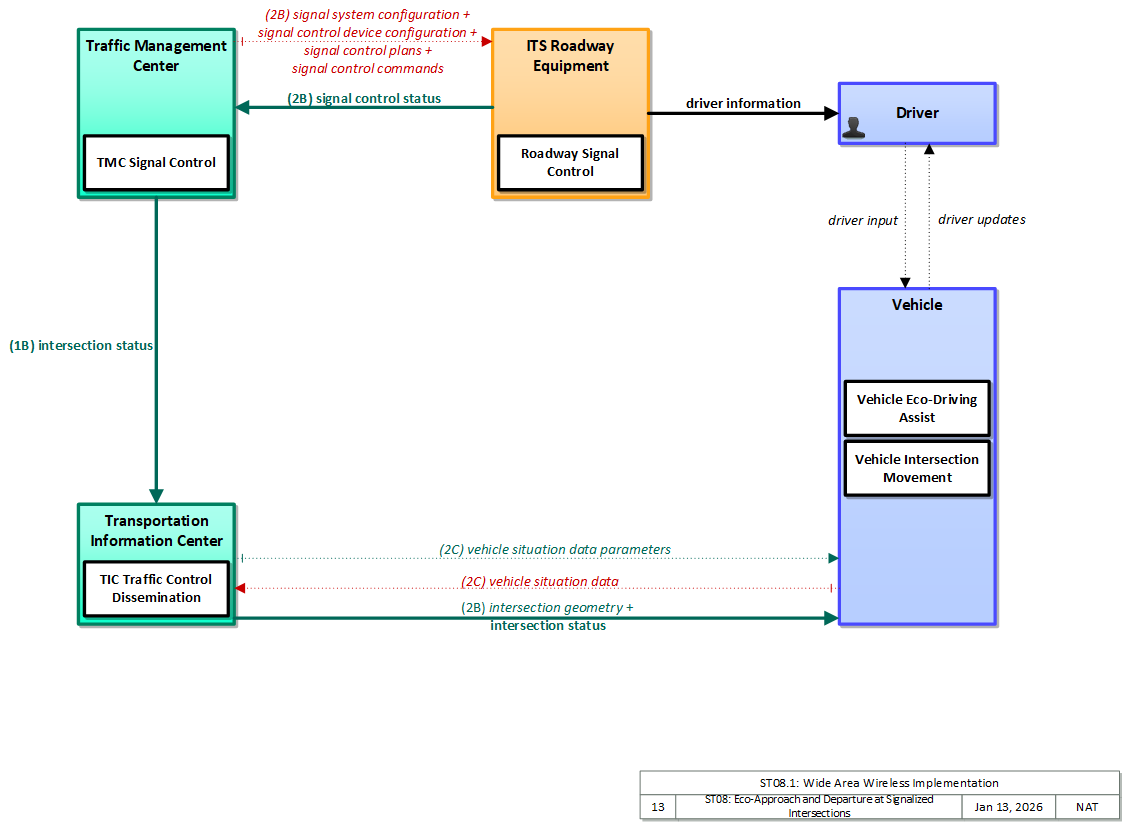

Includes Physical Objects:
| Physical Object | Class | Description |
|---|---|---|
| Driver | Vehicle | The 'Driver' represents the person that operates a vehicle on the roadway. Included are operators of private, transit, commercial, and emergency vehicles where the interactions are not particular to the type of vehicle (e.g., interactions supporting vehicle safety applications). The Driver originates driver requests and receives driver information that reflects the interactions which might be useful to all drivers, regardless of vehicle classification. Information and interactions which are unique to drivers of a specific vehicle type (e.g., fleet interactions with transit, commercial, or emergency vehicle drivers) are covered by separate objects. |
| ITS Roadway Equipment | Field | 'ITS Roadway Equipment' represents the ITS equipment that is distributed on and along the roadway that monitors and controls traffic and monitors and manages the roadway. This physical object includes traffic detectors, environmental sensors, traffic signals, highway advisory radios, dynamic message signs, CCTV cameras and video image processing systems, grade crossing warning systems, and ramp metering systems. Lane management systems and barrier systems that control access to transportation infrastructure such as roadways, bridges and tunnels are also included. This object also provides environmental monitoring including sensors that measure road conditions, surface weather, and vehicle emissions. Work zone systems including work zone surveillance, traffic control, driver warning, and work crew safety systems are also included. |
| Traffic Management Center | Center | The 'Traffic Management Center' monitors and controls traffic and the road network. It represents centers that manage a broad range of transportation facilities including freeway systems, rural and suburban highway systems, and urban and suburban traffic control systems. It communicates with ITS Roadway Equipment and Connected Vehicle Roadside Equipment (RSE) to monitor and manage traffic flow and monitor the condition of the roadway, surrounding environmental conditions, and field equipment status. It manages traffic and transportation resources to support allied agencies in responding to, and recovering from, incidents ranging from minor traffic incidents through major disasters. |
| Transportation Information Center | Center | The 'Transportation Information Center' collects, processes, stores, and disseminates transportation information to system operators and the traveling public. The physical object can play several different roles in an integrated ITS. In one role, the TIC provides a data collection, fusing, and repackaging function, collecting information from transportation system operators and redistributing this information to other system operators in the region and other TICs. In this information redistribution role, the TIC provides a bridge between the various transportation systems that produce the information and the other TICs and their subscribers that use the information. The second role of a TIC is focused on delivery of traveler information to subscribers and the public at large. Information provided includes basic advisories, traffic and road conditions, transit schedule information, yellow pages information, ride matching information, and parking information. The TIC is commonly implemented as a website or a web-based application service, but it represents any traveler information distribution service. |
| Vehicle | Vehicle | This 'Vehicle' physical object is used to model core capabilities that are common to more than one type of Vehicle. It provides the vehicle-based general sensory, processing, storage, and communications functions that support efficient, safe, and convenient travel. Many of these capabilities (e.g., see the Vehicle Safety service packages) apply to all vehicle types including personal vehicles (including motorcycles), commercial vehicles, emergency vehicles, transit vehicles, and maintenance vehicles. From this perspective, the Vehicle includes the common interfaces and functions that apply to all motorized vehicles. The radio(s) supporting V2V and V2I communications are a key component of the Vehicle. Both one-way and two-way communications options support a spectrum of information services from basic broadcast to advanced personalized information services. Advanced sensors, processors, enhanced driver interfaces, and actuators complement the driver information services so that, in addition to making informed mode and route selections, the driver travels these routes in a safer and more consistent manner. This physical object supports all six levels of driving automation as defined in SAE J3016. Initial collision avoidance functions provide 'vigilant co-pilot' driver warning capabilities. More advanced functions assume limited control of the vehicle to maintain lane position and safe headways. In the most advanced implementations, this Physical Object supports full automation of all aspects of the driving task, aided by communications with other vehicles in the vicinity and in coordination with supporting infrastructure subsystems. |
Includes Functional Objects:
| Functional Object | Description | Physical Object |
|---|---|---|
| Roadway Signal Control | 'Roadway Signal Control' includes the field elements that monitor and control signalized intersections. It includes the traffic signal controllers, detectors, conflict monitors, signal heads, and other ancillary equipment that supports traffic signal control. It also includes field masters, and equipment that supports communications with a central monitoring and/or control system, as applicable. The communications link supports upload and download of signal timings and other parameters and reporting of current intersection status. It represents the field equipment used in all levels of traffic signal control from basic actuated systems that operate on fixed timing plans through adaptive systems. It also supports all signalized intersection configurations, including those that accommodate pedestrians. In advanced, future implementations, environmental data may be monitored and used to support dilemma zone processing and other aspects of signal control that are sensitive to local environmental conditions. | ITS Roadway Equipment |
| TIC Traffic Control Dissemination | 'TIC Traffic Control Dissemination' serves as intermediary between transportation operations centers (e.g., TMC, Transit MC) and transportation users (e.g., vehicles, personal devices). It collects and disseminates intersection status, lane control information, special vehicle alerts, and other traffic control related information that is real-time or near real-time in nature and relevant to vehicles in a relatively local area on the road network. It collects traffic control information from Traffic Management and other Center(s) and disseminates the relevant information to vehicles and other mobile devices. | Transportation Information Center |
| TMC Signal Control | 'TMC Signal Control' provides the capability for traffic managers to monitor and manage the traffic flow at signalized intersections. This capability includes analyzing and reducing the collected data from traffic surveillance equipment and developing and implementing control plans for signalized intersections. Control plans may be developed and implemented that coordinate signals at many intersections under the domain of a single Traffic Management Center and are responsive to traffic conditions and adapt to support incidents, preemption and priority requests, pedestrian crossing calls, etc. This may include adaptive traffic control systems (ATCS) that adjust signal timings based on traffic conditions, demand, and system capacity. It also supports all signalized intersection configurations, including those that accommodate pedestrians. | Traffic Management Center |
| Vehicle Eco-Driving Assist | 'Vehicle Eco-Driving Assist' provides customized real-time driving advice to drivers, allowing them to adjust behaviors to save fuel and reduce emissions. This advice includes recommended driving speeds, optimal acceleration and deceleration profiles based on prevailing traffic conditions, and local interactions with nearby vehicles, i.e., processing Basic Safety Messages (BSMs) to determine position and speed of vehicles that are between the host vehicle and the intersection. When approaching and departing signalized intersections, it uses intersection geometry information, the relative position and speed of vehicles ahead of it, and signal phase movement information to provide speed advice to the driver so that the driver can adapt the vehicle’s speed to pass the next traffic signal on green, decelerate to a stop in the most eco-friendly manner, or manage acceleration as the vehicle departs from a signalized intersection. It also provides feedback to drivers on their driving behavior to encourage them to drive in a more environmentally efficient manner. It may also support vehicle-assisted strategies, where the vehicle automatically implements the eco-driving strategy (e.g., changes gears, switches power sources, or reduces its speed in an eco-friendly manner as the vehicle approaches a traffic signal or queue). | Vehicle |
| Vehicle Intersection Movement | 'Vehicle Intersection Movement' uses short-range wireless communications to monitor other connected vehicles at intersections and support the safe movement of the vehicle through the intersection by receiving and processing signal phase and timing messages from the intersection. Driver warnings are provided and the application may also optionally take control of the vehicle to avoid collisions, in coordination with Vehicle Control Automation. The application will also notify the infrastructure and other vehicles if it detects an unsafe infringement on the intersection. | Vehicle |
Includes Information Flows:
| Information Flow | Description |
|---|---|
| driver information | Regulatory, warning, guidance, and other information provided to the driver to support safe and efficient vehicle operation. |
| driver input | Driver input to the vehicle on-board equipment including configuration data, settings and preferences, interactive requests, and control commands. |
| driver updates | Information provided to the driver including visual displays, audible information and warnings, and haptic feedback. The updates inform the driver about current conditions, potential hazards, and the current status of vehicle on-board equipment. |
| intersection geometry | The physical geometry of an intersection covering the location and width of each approaching lane, egress lane, and valid paths between approaches and egresses. This flow also defines the location of stop lines, cross walks, specific traffic law restrictions for the intersection (e.g., turning movement restrictions), and other elements that support calculation of a safe and legal vehicle path through the intersection. |
| intersection status | Current signal phase and timing information for all lanes at a signalized intersection. This flow identifies active lanes and lanes that are being stopped and specifies the length of time that the current state will persist for each lane. It also identifies signal priority and preemption status and pedestrian crossing status information where applicable. It may also include future signal phase and timing information. |
| signal control commands | Control of traffic signal controllers or field masters including clock synchronization. |
| signal control device configuration | Data used to configure traffic signal control equipment including local controllers and system masters. |
| signal control plans | Traffic signal timing parameters including minimum green time and interval durations for basic operation and cycle length, splits, offset, phase sequence, etc. for coordinated systems. |
| signal control status | Operational and status data of traffic signal control equipment including operating condition and current indications. |
| signal system configuration | Data used to configure traffic signal systems including configuring control sections and mode of operation (time based or traffic responsive). |
| vehicle situation data | This flow represents vehicle snapshots that may be provided by the vehicle to support traffic and environmental conditions monitoring. Snapshots are collected by the vehicle for specific events (e.g., when a sensor exceeds a threshold) or periodically and reported based on control parameters when communications is available. Traffic-related data includes snapshots of measured speed and heading and events including starts and stops, speed changes, and other vehicle control events. Environmental data may include measured air temperature, exterior light status, wiper status, sun sensor status, rain sensor status, traction control status, anti-lock brake status, and other collected vehicle system status and sensor information. The collected data is reported along with the location, heading, and time that the data was collected. |
| vehicle situation data parameters | A request for vehicle situation data that includes parameters used to control the data that is reported and the flow of data reported by the vehicle. This flow identifies the type of data/snapshots that are requested and reporting parameters such as snapshot frequency, filtering criteria (data thresholds for reporting), and reporting interval. |
Goals and Objectives
Associated Planning Factors and Goals
| Planning Factor | Goal |
|---|---|
| E. Protect and enhance the environment, promote energy conservation, improve the quality of life, and promote consistency between transportation improvements and State and local planned growth and economic development patterns; | Protect/Enhance the Environment |
Associated Objective Categories 
| Objective Category |
|---|
| Environment: Clean Air |
| System Efficiency: Energy Consumption |
Associated Objectives and Performance Measures
Needs and Requirements
| Need | Functional Object | Requirement | ||
|---|---|---|---|---|
| 01 | Traffic Operations needs to be able to provide both intersection geometry and signal phase and timing information to vehicles. | Roadway Signal Control | 01 | The field element shall control traffic signals under center control. |
| 04 | The field element shall report the current signal control information to the center. | |||
| 15 | The field element shall provide to roadside equipment the intersection geometry and signal phase movement information including phase and timing information, alarm status, and priority/preempt status. | |||
| TIC Traffic Control Dissemination | 03 | The center shall provide real time signal phase and timing information for all lanes at a signalized intersection to vehicle. | ||
| TMC Signal Control | 01 | The center shall remotely control traffic signal controllers. | ||
| Vehicle Eco-Driving Assist | 01 | The vehicle shall receive the current signal phase and timing information for all lanes at a signalized intersection. | ||
| Vehicle Intersection Movement | 07 | The vehicle shall receive intersection signal timing information in order for the vehicle to determine the best approach to maximizing efficiency while preserving safety. | ||
| 02 | The vehicle drivers need their connected vehicle to provide recommendations for movement approaching or departing a signalized intersection in order to reduce the environmental impact of their vehicle’s operations. | Vehicle Eco-Driving Assist | 02 | The vehicle shall provide recommendations for movement approaching or departing a signalized intersection in order to pass the next traffic signal on green or to decelerate to a stop in the most eco-friendly manner. |
| Vehicle Intersection Movement | 01 | The vehicle shall provide vehicle path information to identify if vehicle is performing an unpermitted movement at an intersection such as a stop sign violation or running a red light. | ||
| 02 | The vehicle shall provide data describing the vehicle's location in three dimensions, heading, speed, acceleration, braking status, and size. | |||
| 07 | The vehicle shall receive intersection signal timing information in order for the vehicle to determine the best approach to maximizing efficiency while preserving safety. | |||
| 03 | The connected vehicle needs to be able to automatically adjust its operating parameters approaching or departing a signalized intersection in order to reduce the environmental impact of the vehicle’s operation. | Vehicle Eco-Driving Assist | 03 | The vehicle shall automatically adjust its operating parameters approaching or departing a signalized intersection. |
Related Sources
| Document Name | Version | Publication Date |
|---|---|---|
| None |
Security
In order to participate in this service package, each physical object should meet or exceed the following security levels.
| Physical Object Security | ||||
|---|---|---|---|---|
| Physical Object | Confidentiality | Integrity | Availability | Security Class |
| ITS Roadway Equipment | Moderate | High | Moderate | Class 3 |
| Traffic Management Center | Moderate | High | Moderate | Class 3 |
| Transportation Information Center | Moderate | High | Moderate | Class 3 |
| Vehicle | Moderate | Moderate | Moderate | Class 2 |
In order to participate in this service package, each information flow triple should meet or exceed the following security levels.
| Information Flow Security | |||||
|---|---|---|---|---|---|
| Source | Destination | Information Flow | Confidentiality | Integrity | Availability |
| Basis | Basis | Basis | |||
| Driver | Vehicle | driver input | Moderate | High | High |
| Data included in this flow may include origin and destination information, which should be protected from other's viewing as it may compromise the driver's privacy. | Commands from from the driver to the vehicle must be correct or the vehicle may behave in an unpredictable and possibly unsafe manner | Commands must always be able to be given or the driver has no control. | |||
| ITS Roadway Equipment | Driver | driver information | Not Applicable | High | Moderate |
| This data is sent to all drivers and is also directly observable, by design. | This is the primary signal trusted by the driver to decide whether to go through the intersection and what speed to go through the intersection at; if it’s wrong, accidents could happen. | If the lights are out you have to get a policeman to direct traffic – expensive and inefficient and may cause a cascading effect due to lack of coordination with other intersections. | |||
| ITS Roadway Equipment | Traffic Management Center | signal control status | Low | High | Moderate |
| The current conditions of an ITS RE are completely observable, by design. | This influences the TMC response to a right-of-way request. It should be as accurate as the right-of-way request themselves. For some applications (ISIG) this need only be moderate. Per THEA: info needs to be accurate and should not be tampered to enable effective monitoring and control by the TMC. DISC: THEA believes this to be MODERATE: "info needs to be accurate and should not be tampered to enable effective monitoring and control by the TMC; should be as accurate as the right of way request". NYC:TMC doesn’t play an active role in this application, i.e. even if the information contained in this flow were incorrect, it is unlikely to affect the outcome of this application one way or the other. On some applications NYC has this MODERATE though. RES: This value can obviously change a lot depending on the application context. | The TMC will need the current status of the ITS RE in order to make an educated decision. If it is unavailable, the system is unable to operate. However, a few missed messages will not have a catastrophic impact. From NYC: TMC doesn’t play an active role in this application, i.e. even if it is unavailable, it is unlikely to affect the outcome of this application one way or the other. RES: This value can change a lot depending on the application context. | |||
| Traffic Management Center | ITS Roadway Equipment | signal control commands | Moderate | High | Moderate |
| Control flows, even for seemingly innocent devices, should be kept confidential to minimize attack vectors. While an individual installation may not be particularly impacted by a cyberattack of its sensor network, another installation might be severely impacted, and different installations are likely to use similar methods, so compromising one leads to compromising all. DISC: NYC believes this to be LOW: "The result of this will be directly observable." | Invalid messages could lead to an unauthorized user gaining control of an intersection. This could also be used to bring traffic to a standstill, which could lead to a large financial impact on the community. DISC: NYC believes this to be MODERATE: The signal timing is critical to the intersection operation; incorrect signal timing can lead to significant congestion and unreliable operation; while unsafe operation is controlled by the cabinet monitoring system, attackers could “freeze” the signal or call a preemption. RES: This will vary depending on the application and implementation. | These messages are important to help with preemption and signal priority applications. Without them, these applications mayl not work. However, if these signals are not received, the ITS RE will continue to function using its default configuration. The TMC should have an acknowledgement of the receipt of a message. DISC: NYC blieves this to be LOW: TMC doesn’t play an active role in this application, i.e. even if it is unavailable, it is unlikely to affect the outcome of this application one way or the other. RES: This will vary depending on the application and implementation. | |||
| Traffic Management Center | ITS Roadway Equipment | signal control device configuration | Moderate | High | Moderate |
| Control flows, even for seemingly innocent devices, should be kept confidential to minimize attack vectors. While an individual installation may not be particularly impacted by a cyberattack of its sensor network, another installation might be severely impacted, and different installations are likely to use similar methods, so compromising one leads to compromising all. DISC: THEA believes this to be LOW: "encrypted, authenticated, proprietary; however will not cause harm if seen, traffic light information is visible." | Control flows, even for seemingly innocent devices, should have MODERATE integrity at minimum, just to guarantee that intended control messages are received. Incorrect, corrupted, intercepted and modified control messages can or will result in target field devices not behaving according to operator intent. The severity of this depends on the type of device, which is why some devices are set MODERATE and some HIGH. From THEA: proprietary info that should not be tampered with; includes local controllers and system masters; tampering with configurations could cause delays along with major safety issues | Control flow availability is related to the criticality of being able to remotely control the device. For most devices, this is MODERATE. For purely passive devices with no incident relationship, this will be LOW. All devices should have default modes that enable them to operate without backhaul connectivity, so no device warrants a HIGH. From THEA: should be timely and readily available; however, should be able to function using a default configuration | |||
| Traffic Management Center | ITS Roadway Equipment | signal control plans | Moderate | High | Moderate |
| Control flows, even for seemingly innocent devices, should be kept confidential to minimize attack vectors. While an individual installation may not be particularly impacted by a cyberattack of its sensor network, another installation might be severely impacted, and different installations are likely to use similar methods, so compromising one leads to compromising all. DISC: THEA believes this to be LOW: "encrypted, authenticated, proprietary; but the result is directly observable from traffic lights | Control flows, even for seemingly innocent devices, should have MODERATE integrity at minimum, just to guarantee that intended control messages are received. Incorrect, corrupted, intercepted and modified control messages can or will result in target field devices not behaving according to operator intent. The severity of this depends on the type of device, which is why some devices are set MODERATE and some HIGH. From THEA: proprietary info that should not be tampered with; tampering with these plans could cause delays along with major safety issues | Control flow availability is related to the criticality of being able to remotely control the device. For most devices, this is MODERATE. For purely passive devices with no incident relationship, this will be LOW. All devices should have default modes that enable them to operate without backhaul connectivity, so no device warrants a HIGH. From THEA: should be timely and readily available; coordinated with other systems; however, should be able to function using a default configuration | |||
| Traffic Management Center | ITS Roadway Equipment | signal system configuration | Low | High | Moderate |
| encrypted, authenticated, proprietary; however, the result is directly observable from traffic lights | proprietary info that should not be tampered with; data used to configure traffic signal systems; could cause significant delays and traffic issues if compromised | should be readily available; configurations can be time | |||
| Traffic Management Center | Transportation Information Center | intersection status | Not Applicable | High | Moderate |
| This data is distributed using a variety of mechanisms, some of which are localized broadcast; it is desireable that all potential users get this information. | If this flow is not accurate or delivered in a timely fashion then a large variety of mobility and safety services that depend on it will not work properly. | If this flow is not accurate or delivered in a timely fashion then a large variety of mobility and safety services that depend on it will not work properly. | |||
| Transportation Information Center | Vehicle | intersection geometry | Low | High | Moderate |
| Map data intended for general use by any C-ITS component than needs it. No information here includes PII or anything else that, if viewed by someone other than the participant, would lead to harm. | Map data is used for a host of application purposes. This widespread use means that any corruption in the data has a widespread and far reaching effect. | Occasional outages of this flow will delay updates and lead to a loss of accurate function of some applications. Depending on the application this could be HIGH. | |||
| Transportation Information Center | Vehicle | intersection status | Not Applicable | High | Moderate |
| This data is distributed using a variety of mechanisms, some of which are localized broadcast; it is desireable that all potential users get this information. | If this flow is not accurate or delivered in a timely fashion then a large variety of mobility and safety services that depend on it will not work properly. | If this flow is not accurate or delivered in a timely fashion then a large variety of mobility and safety services that depend on it will not work properly. | |||
| Transportation Information Center | Vehicle | vehicle situation data parameters | Low | Moderate | Moderate |
| This isn't exactly a control flow, more like a 'suggestion flow', as the vehicle will always decide what to send. Probably no need for obfuscation. | Info should be accurate and should not be tampered so that the vehicle only discloses the correctly requested data | Parameters should be timely and readily available, but would not have severe/catastrophic consequences if not | |||
| Vehicle | Driver | driver updates | Not Applicable | Moderate | Moderate |
| This data is informing the driver about the safety of a nearby area. It should not contain anything sensitive, and does not matter if another person can observe it. | This is the information that is presented to the driver. If they receive incorrect information, they may act in an unsafe manner. However, there are other indicators that would alert them to any hazards, such as an oncoming vehicle or crossing safety lights. | If this information is not made available to the driver, then the system has not operated correctly. | |||
| Vehicle | Transportation Information Center | vehicle situation data | Moderate | Moderate | Low |
| Might be able to link multiple snapshots together and compromise some element of driver/traveler privacy. | Event driven data can be used for various mobility monitoring applications, and as operational decisions may be made based on mobility conditions, this data's accuracy should be preserved or decisions may not align with real situations. | While desireable, in most application contexts the provision of a single vehicle's data through this flow is not critical. | |||
Standards
The diagram here shows the primary standards associated with the physical objects and information flows in this service package. Click on the standard # to go to the page explaining that standard in more detail. The tables that follow the diagram list the standards associated with the information flows in this service package that should drive development decisions. Click on the standard name for more information from the Communications View about a particular standard, including the solutions and information flow triples associated with the standard and any gaps or overlaps. This table is based primarily on standards used in North America. For information concerning standards and communications solutions in other regions consult the Communications View.
This material should be considered 'draft for review' and may change separately from ARC-IT version revisions. The date on the diagram relates to the date of the physical service package diagram on which this is based; standards-related information should be considered up-to-date as of the 'last updated' date on this page.
Communication Standards: Standards associated with data, message or dialog definitions, communications protocols and management and security of data exchanges. All standards here are also illustrated in information flow triple communications view diagrams.
| Name | Title |
|---|---|
| ITS Application Entity | |
| NTCIP 1202 Signal Controller Objects | NTCIP Object Definitions for ASC |
| NTCIP 1210 Signal System Master Objects | NTCIP Objects for Signal System Masters |
| SAE J2735 DSRC Message Set | V2X Communications Message Set Dictionary |
| SAE J2945/A Road Geometry | Minimum Requirements for Road Geometry and Attributes Definition |
| Facilities Layer | |
| Bundle: ISO 15784-2 | Intelligent transport systems (ITS) -- Data exchange involving roadside modules communication -- Part 2: Centre to field device communications using SNMP |
| SAE J2945 DSRC Common Design Elements | Dedicated Short Range Communication (DSRC) Systems Engineering Process Guidance for J2945/x Documents and Common Design Concepts |
| Security Entity | |
| IETF RFC 6353 TLS for SNMP | Transport Layer Security (TLS) Transport Model for the Simple Network Management Protocol (SNMP) |
| IETF RFC 9456 TLS Updates for SNMP | Updates to the TLS Transport Model for SNMP |
| ITS Security Alternatives | ITS Security Alternative Set |
| Secure Session Alternatives | Secure Session Alternatives |
| Management Entity | |
| Bundle: SNMPv3 MIB | SNMPv3 & Networking MIBs |
| NTCIP 1201 Global Objects | NTCIP Global Object (GO) Definitions |
| Networking and Transport Layer | |
| Internet Transport Alternatives | Internet Transport Alternatives |
| IP Alternatives | Internet Protocol Alternative Set |
| Access Layer | |
| Field SubNet Alternatives | Field SubNet Alternatives |
| Internet Subnet Alternatives | Internet Subnet Alternatives |
| Wireless Internet Alternatives (NA) | Wireless Internet Alternatives according to North American standards |
Physical Standards: Standards associated with device physical, environmental or performance requirements.
The following table lists the standards associated with physical objects in this service package. Click on the standard name for more information about a particular standard.
| Name | Title |
|---|---|
| ISO 15623 Fwd Collision Performance | Intelligent transport systems -- Forward vehicle collision warning systems -- Performance requirements and test procedures |
| ISO 24100 Probe Vehicle Data Protection | Intelligent transport systems -- Basic principles for personal data protection in probe vehicle information services |
| ITE 5201 ATC | Advanced Transportation Controller |
| ITE 5202 ATC Model 2070 | Model 2070 Controller Standard |
| ITE 5301 ATC ITS Cabinet | Intelligent Transportation System Standard Specification for Roadside Cabinets |
| ITE 5401 ATC API | Application Programming Interface Standard for the Advanced Transportation Controller |
| NEMA TS 8 Cyber and Physical Security | Cyber and Physical Security for Intelligent Transportation Systems |
| NEMA TS2 Traffic Controller Assemblies | Traffic Controller Assemblies with NTCIP Requirements |
| SAE J3361 Antenna requirements | V2X Antenna Coverage and Test Requirements for US FHWA Class 1 and Class 3-13 Class Vehicles |
| SAE J5001 OBU Standard | Onboard Unit Standard for Connected Vehicles |
Service-Level Standards: Standards associated service package structure, messaging patterns, user needs, requirements or similar systems-engineering content that describe one or more use cases satisfied by the service package.
The following table lists the standards that are associated with the service package as a whole. Click on the standard name for more information about a particular standard.
| Name | Title |
|---|---|
| CTI 4501 CI Implementation Guide | Connected Intersections Implementation Guide |
System Requirements
| No System Requirements |